Not a very clear map, so I hope I get this right. Road on the right is Tower Bridge Road, the first road going left is Webb Street, with Webb Street School left, the second road left is Swan Mead then Leroy Street. Pages Walk is on the left of the picture with the Bricklayers Arms Railway Depot far left. The first building middle left in Pages Walk is Harold Estate, then heading towards Old Kent Road you have Guinness’s Buildings, then Pages Walk School. Top of picture (middle) is Barnaby Buildings, Leroy Street. The white space in the middle is the park in Leroy Street, with Swan Mead just before it, and Stewart House just to the right. I’m not sure of this but the large buildings, bottom left I think was a Tannery.?
No date but after WW2. You can see where Guinness’s Building was bombed. Now it is a bit confusing for me as I cannot remember any white squares opposite the park, also the long white buildings in Webb Street is where Worthing Buildings was, I left there in the early 1960s, so I assume the picture is after that.

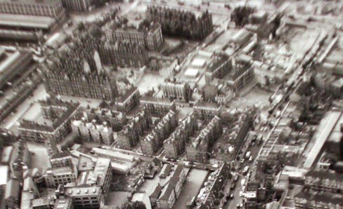
- Tower Bridge Road right Pages Walk left.